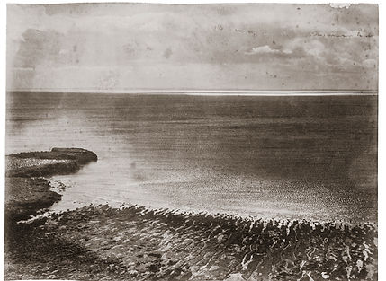

231 ° SW / 42 ° 34 '39 "S / 64 ° 16' 32" W
.


211 ° SW / 42 ° 35 '5 "S / 64 ° 18' 31" W


52 ° NE / 42 ° 35 '5 "S / 64 ° 18' 37" W


314 ° NW / 42 ° 37 '5 "S / 64 ° 16' 25" W


280 ° W / 42 ° 25 '26 "S / 64 ° 8' 46" W


350 ° N / 42 ° 25 '33 "S / 64 ° 8' 33" W
The project consists on recreating images that were taken 120 years ago in Peninsula Valdes, Patagonia Argentina. I want to show just
what has changed—and what hasn’t -. As a starting point I took as a reference a photographic archive from the year 1900. The proposal
is to reconstruct an image looking for the old footprint of the pioneer photographer.
I am interested in recording the changes of nature on the landscape over time. This reconstruction does not only consist in establishing
the transformation of the landscape by natural erosion, but in making an effort to look at nature from the same point of view as the
pioneer photographer. It is the reconstruction of a point of view, the act of putting oneself in the place of the other, the action of putting
the body in the same place of another body that inhabited that past.
Once the landscape was found, the first step was to dismember it into its different variables to achieve the most accurate image possible
to the previous one. I needed to organice it, divide it, distribute levels, distinguish what is relevant from what is not, describe
relationships and elaborate discourses. The variables that I took as a reference were: the tide, wind, the light to determine the time of
the shot and the cloudiness.